
Memorial
Title
Title
Derwent Woodlands

Images
|
|
|
|
Locations
Roadside
Western Access Road
Derwent
Derbyshire
S33 0AQ
NGR:
SK 18262 88300
(From online digital mapping)
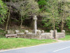
On the southwestern side of the un-named western access road to Derwent and Howden Dams, about 2km north of the junction with Snake Pass or Snake Rd (A57).
Roadside
Un-named road
Derwent
Derbyshire
S33 0AQ
NGR:
SK 18395 88500
(From online digital mapping)
It is believed that the memorial was located near the school at the southern end of the village, on the southeastern side of the junction of the road leading through the village and the lane towards Derwent Hall. It was sited behind a stone wall on a bank. The memorial was dismantled prior to the flooding of the village to create the Ladybower Reservoir about 1940, and was subsequently reconstructed on its new site overlooking the former village.
Type
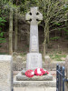
Originally a coarsely dressed sandstone wheel cross on a battered square pedestal with dressed arisses. The inscription panel on the cross shaft, and the name panel on the pedestal, have incised upright capital lettering coloured black.
When relocated the base was replaced by three sandstone steps, dressed on the upper surfaces but roughly dressed at the sides, and surrounded by stone and gravel paving and an ashlar sandstone wall with wrought iron gate.
| Component | Material | Height | Width | Depth | Condition |
| Cross | Sandstone | 2460 | 800 | 330 | Good |
| Pedestal | Sandstone | 860 | 750 | 750 | Good |
| Base | Sandstone | 610 | 2000 | 2000 | Good |
| Paving | Stone, gravel | - | - | - | Good |
| Wall | Sandstone | 1330 | 7000 | 7500 | Good |
| Gate | Wrought iron | 1150 | 910 | - | Good |
| Dimensions in millimetres ±5mm unless stated otherwise. | |||||
Inscription
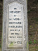
| 6 o’clock face of cross shaft: | IN MEMORY OF THE MEN OF DERWENT- WOODLANDS WHO FELL IN THE GREAT WAR 1914 – 1918 |
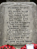
6 o’clock face of pedestal: |
PTE. GEORGE COTTRILL K.R.R. PTE. ARTHUR DAKIN NOTTS & DERBY REGT. CORPL. GEORGE DUNN YORK & LANCS REGT. PTE. WILFRED EYRE YORK & LANCS REGT. PTE. WALTER HEATHCOTE YORK & LANCS REGT. GDS. DAVID KENNEDY GRENADIER GUARDS. PTE. JASON PRIESTLEY NOTTS & DERBY REGT. GDS. GREGORY THORP GRENADIER GUARDS. PTE. JOHN WILSON NOTTS & DERBY REGT. DRV. JOHN JOSEPH THORP R.F.A. |
| Conflicts and people commemorated | ||
| Conflict | First World War (1914-1919) | |
| Number died | 10 | |
| Number served and returned | 0 | |
| Total names | 10 | |
Administration
The memorial lies within the catchment of the Ladybower Reservoir, owned by Severn Trent Water Ltd.
Local Authorities:
In the original location, after WW1: Derwent Parish Council; Chapel en le Frith Rural District Council; Derbyshire County Council
In the new location, after WW2: Hope Woodlands Parish Council; Chapel en le Frith Rural District Council; Derbyshire County Council
Since 1974: Hope Woodlands Parish Council; High Peak Borough Council; Derbyshire County Council.
History
17th May, 2010: Surveyed by Roy Branson and Alan Willmot.
References
The Flickr web page contains a photograph of the memorial in its original location.
Comments